
Walk 18 - Harbottle Crags - Moderate Route
Distance: 6 miles (9.7 km)
Maps: Explorer OL16.
Walking time: 2 ½ hours
Start and Finish point: Harbottle Castle Car Park (Northumberland National Park car park). This car park is situated just at the far side of Harbottle village, as you drive up the Coquetdale valley (grid reference NT 933047).
DOWNLOAD the self led walking guide for Harbottle Crags here.
Summary
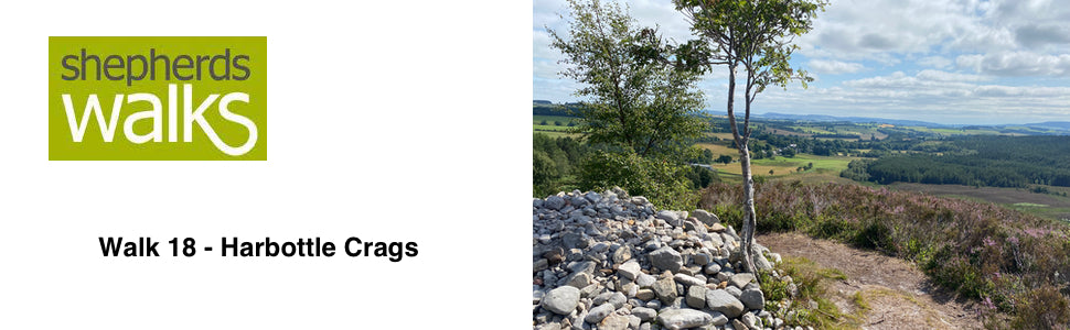
This lovely walk explores the Harbottle Crags, a nature reserve managed by Northumberland Wildlife Trust. From the summit of the crags you are treated to some spectacular views of the quaint village of Harbottle situated down below.
After you descend through a wooded section you follow a track where again the views of the Cheviot Hills in the distance takes your breath away. You then return back into the village following the ‘Border County Ride’, which takes in a restored limekiln before dropping back down to the river Coquet with its abundance of wildlife.
There is a short distance on the walk that is situated on the edge of Otterburn training area. The paths used for this walk are open to public use all the time (even when the red flags are flying). The walk has been cleared personally with the Range Control Officer.
The route is good under foot but strong shoes are recommended.
Route Details
From the car park go back on to the road and turn right along it. Walk on the right- hand side of the road so that you are facing any oncoming traffic.
After a short distance you pass a house on your left-hand side. Immediately after the house is a wooden gate leading into a wall-lined field (signpost - Harbottle Lake ¾). Pass through the gate and walk half-right across the field in the direction of the signpost to the top right corner, just in front of the forest. As you approach the corner you will see a three stepped stile built into the wall. This is situated a little way down from the corner you originally were heading for.
Cross the stile, walk through the woodland for a very short distance until you reach a very broad path. Turn left along it and pass through the small gate located to the right of a larger one taking you in to the sign posted ‘Harbottle Crags Nature Reserve’.
Follow the broad path, as it bears to your right and rises up, running parallel to the forest boundary on your right. Continue on the well-trodden path with the heather on each side.
Pass through the kissing gate taking you through a fence line.
Continue to rise on the path and just off to your left is a prominent cairn at which lovely views of the lower lying ground and village can be seen.
From here it certainly makes you appreciate how the ground surrounding the village has been improved. It has been walled off and over many generations the farmers have reseeded and fertilised to improve the pasture and make it more productive.
As you reach a fork in the path you have two alternatives. Bear left and take a short detour up to the ‘Drake Stone’, which is also the best vantage point on the walk, or continue on.
If you wish to view the ‘Drake Stone’ bear left, pass the bench dedicated to Roy Wells (1942 – 2000) on your right and follow the path up to the summit. The ‘Drake Stone’ can be found at the summit surrounded by rocks, which have been scratched and polished by the ice sheet of the last glacial period. Retrace your steps back to the main path.
If you have viewed or do not wish to view it continue on the main path as it rises bearing slightly right, still running parallel to the forest on your right. Just before you reach the lake you come to a marker post with an arrow on it. Walk in the direction of the arrow to the stile, in the fence line, cross it and walk in the direction of the arrow on the stile, which is pointing towards the lake, as you continue on the prominent path.
The path runs along the bank of Harbottle Lake. This lake is situated 270 metres (approx. 900 feet) above sea level. At the eastern end of the lake a peat bog has been formed from a layer of sphagnum moss growing over deep water. Please keep to the path as the bog is extremely dangerous and could result in one drowning.
The bog flora includes the carnivorous round-leaved sundew, whilst the damp flushes contain bog myrtle.
You reach a stile just in front of a military warning sign, indicating that you are about to enter a military firing range. Cross the stile and walk in the direction of the yellow arrow, pointing up to your right as you head up away from the lake, following the fence on your right, weaving your way up through the heather.
This walk just skirts the edge of the training area and has been cleared personally with the Range Control Officer. Some 30,000 soldiers a year come to Otterburn to train for periods between two days and two weeks. British and NATO troops fire weapons and NATO practice air-to-ground attacks. Otterburn training area is particular challenging for infantry and artillery fire and for manoeuvre training. The area you are walking on is classed as a ‘dry training area’.
Just before reaching the forest, the path bears away from the fence before you drop down to the forest boundary. Turn right along this fence and walk into the corner to a stile on your left leading into the forest.
At the time of writing two trees had fallen on to the stile in the corner, hiding it. Therefore you will need to cross into the forest by climbing over a wooden ‘slip hurdle’ situated next to it. A ‘slip hurdle’ is an un-hinged gate that slides to open. After climbing over into the forest, turn left and pass a concrete fence post on to the obvious path between the trees.
The path through the forest is following the line of an old, broken-down fence which once would have been supported by concrete posts. At certain stages there are trees lying across the path. A slight detour soon gets you round these and back on the path. This detour is made easier as you know the path is running in a straight line, due to it following the line of the old fence.
This old fence line is a little unusual. The fence posts have been made out of concrete, rather than the traditional wooden ones, therefore the life expectancy is far longer as they will not rot.
These types of fences are usually erected by large organisations e.g. Forestry Commission, Ministry of Defence and Local Councils. The original cost of erecting a fence using concrete posts would have been high, and unlike wooden posts they can’t be knocked in. Each one would have had to be put into a dug hole and the post would either have been concreted in or held in place by compacted earth. The wire would have been threaded through each post and then this would have been wound tight at wooden ‘strainer posts’. You can view one of these fences at one of the highest points of the path.
At the highest point of this path you are also treated to some lovely views of the summit of Lords Seat in the distance before the path descends down to a small gate leading on to a track.
Pass through this gate and turn right along the track, immediately passing through a metal gate and walk along the broad track leaving the ranges behind you.
On your right you have a broken down wall. If you have a look at it you are given a good profile of how it has been constructed. The wall consists of two separate ones, with a ‘cavity’ in the middle. This is filled with smaller stones. Throughout its height it has two lots of ‘through stones’ which tie in the two outside walls together. The top is finished with some ‘top stones’ or ‘coping stones’ which also ties the two outside walls together.
Just before you drop down you have a good view of Alwinton village away to your left.
Alwinton stands quietly where the rivers Alwin and Coquet meet and is the last village up the Coquet Valley. A single-track road continues past Alwinton up the valley for another 12 miles, passing farmsteads Barrow MiIl, Linbriggs, Shillmoor, Bygate, Barrow Burn, Blind Burn, Fulhope, Makendon and finally the Roman encampment of Chew Green, which is intersected by The Pennine Way.
The track you are following drops down, passing through a metal gate as you continue on the prominent track down to the road.
At the bottom of the track pass through a wooden gate taking you on to the road. Turn left along the road and on your left you are treated to some fine views of the route you have just covered.
Continue along the road as you drop down and cross the river Coquet on the road bridge. If the water level is low you can see the foundations of the old bridge that was situated a few yards downstream. Also on the Alwinton side of the river you can clearly see the old road approaching the site of the old bridge.
After crossing the bridge take your first right (Public Bridleway - Park House ½ mile, Harbottle 1 ¼). Follow this tarmac road, which is part of the ‘Border County Ride’, crossing a cattle grid.
Just after the cattle grid you can see how a single strand ‘barb guard’ has been placed about one yard off the boundary wall for the cottages.
This has been done to stop cattle from scratching and rubbing themselves on the wall and in the process damaging or even demolishing it. Also it stops any cattle reaching over the wall and eating the garden plants.
On your left you can see Low Alwinton Church.
You cross another cattle grid just before you reach Low Alwinton limekiln. This was in use from 1827 to 1866. An information board has been erected by Northumberland National Park at this restored limekiln. Land over a number of years gets more acid, due to the acidity of the rain. Therefore farmers put lime on the ground to try and bring the Ph of the soil as near to neutral as possible. Grasses grow better at this Ph and applying lime to poorer pastures, or even hill ground, is a good way to encourage more productive, palatable pasture to grow.
Continue along the road as it rises up after the limekiln and this is an ideal time to look back at the road bridge you crossed earlier. It makes you realise what a modern structure it is but personally I am not all that keen on the colour.
You approach and pass a number of dwellings and farm buildings on your right, before reaching and passing through a wooden gate with a public bridleway and ‘Border County Ride’ sign on it.
Just a few yards after the gate the track becomes a little less obvious. The fence you have been following on your right bears off through 90 degrees. At this point aim for the corner of the forest, staying on the level, with a small bank on your right-hand side. Upon reaching the forest follow the fence on your left as you gradually drop down to a gate.
Pass through it or cross the stile and follow the prominent route along the edge of the field with a fence on your left and few trees marking the tracks boundaries.
You pass through a metal gate leading into a hardwood planted wood. Follow the path through the wood before you drop down, leaving the wood. Here you pass an idyllic house as you approach the banks of the river Coquet. Follow the track as it runs parallel to the river.
Keep your eyes open for herons standing motionless on the riverbank.
After a little while you take the first right over a grey metal bridge that crosses the river. Keep to the path and turn right along the road passing some houses as you drop down into Harbottle village.
As you join the main road bear right along it. Continue along the road through the village, passing the pub on your right.
As you continue along the road you leave the houses behind and on your right you can see a water trough set back in the wall. This would have been built here in the past to water the horses and livestock that were being ridden and driven up the valley. The trough is more than likely filled from a field drain that will run into the trough to keep it filled up. Any excess water just spills over the front and into another field drain taking it away.
Continue along the road and return to the car park on your right.
Revised January 2004